Sanjeevani Panditharatne is a PhD student in the Space and Atmospheric Physics Group in the Department of Physics. She writes to us from the icy mountains of Andøya, Norway, where she is weathering snow storms to study how cirrus clouds affect the Earth’s warming.
By Sanjeevani Panditharatne
I’m part of a team of three who have headed to Andøya, a remote Norwegian island inside the Arctic circle to better understand the link between high-altitude ice clouds and their climate impact within the far-infrared region!

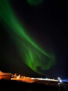
We’re here for a total of six weeks, funded by the European Space Agency, and are working in collaboration with the University of Oslo, Bergen, Gothenburg, Leipzig, and the INCAS Atmos Lab. We’ve seen our fair share of snow storms, the Northern Lights, and really chilly days to get a good taste of that Arctic explorer lifestyle. But why exactly are we here?
What is the far-infrared?
Infrared radiation is familiar to us as radiated heat: whenever you use a radiator to warm your hands, that’s infrared.
The Earth’s Radiation Budget captures the balance between incoming solar radiation and the loss of energy to space through the reflection or emission of infrared radiation. This budget is currently unbalanced because of human activities trapping more and more of this energy, leading to a rise in average global temperatures, otherwise known as global warming. Most of the thermal radiation emitted by Earth is referred to as ‘outgoing longwave radiation’, and models suggest that over half of this is within the longwave part of the infrared region called the far-infrared.
Despite this, the far-infrared spectrum has never been measured before at the top of the atmosphere due to technical limitations. This is due to change with NASA’s Polar Radiant Energy in the Far-InfraRed Experiment mission and the ESA’s Far-infrared Outgoing Radiation Understanding and Monitoring (FORUM) mission. My PhD and research are in support of the latter, as is our expedition to Norway.

Studies have indicated that the far-infrared region is highly sensitive to cirrus clouds: high-altitude ice clouds, which regularly cover around 30 per cent of the Earth. They are composed of ice crystals that can form in a multitude of shapes, sizes, and densities, contributing to the cloud’s overall ability to reflect, scatter, and absorb at different wavelengths. By reflecting shortwave radiation back to space, and absorbing or scattering longwave radiation from the lower atmosphere and surface, cirrus clouds are big players in the Earth’s Radiation Budget.
Some types of cirrus clouds are theorised to have a net warming effect on our climate through an enhanced trapping of the outgoing longwave radiation. However, the limited work done suggests a substantial uncertainty in our current understanding of this, particularly within the far-infrared. In our mission to fight climate change, understanding their role is absolutely vital.
Measuring with FINESSE
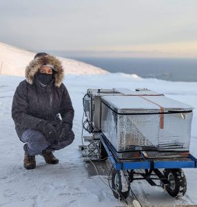
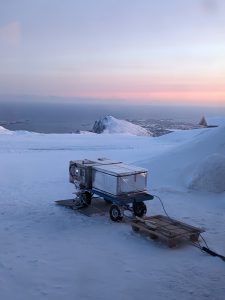
The instrument we’re using is called FINESSE – the Far-INfrarEd Spectrometer for Surface Emissivity – and was developed in the Space and Atmospheric Physics Group at Imperial College London, funded by the NERC National Centre for Earth Observation. Now the clue in the name is that the second science goal of our campaign is to measure the surface emissivity of snow – how effective it is in emitting, in our case, infrared radiation. Just like cirrus clouds, the different snow crystals and density dictate its ability to do so. When we want to measure the effect of cirrus clouds on the far-infrared downwelling radiation, FINESSE is pointed up. When we want to measure the emissivity of snow, FINESSE is pointed down.

FINESSE is stationed at the ALOMAR Observatory on top of Ramnan Peak. While we’ve been here, temperatures have dropped to -15°C and wind speeds have reached over 100mph. Luckily, we weren’t on the peak during those high wind speeds or super cold weather.
There are two major advantages of being in a place like this to take our measurements. The first is that the cold temperatures open up windows in the far-infrared spectrum that allow us to see different features. The second is that atmospheric water vapour is a big absorber in the far-infrared region, and measuring at an altitude of 300m removes a chunk of the atmosphere from our observations, allowing us to see higher up in the atmosphere more clearly.
The ALOMAR Observatory also has a collection of instruments that work similar to radar, known as LIDARs, that are used to profile temperatures, winds, and clouds in the middle and upper atmosphere that we can combine with our measurements.
With FINESSE, we’ve got the spectrum, but it’s also important that we examine the different properties of the snow and ice crystals to link them together. For snow, this involves taking photos of the crystals and classifying them. For cirrus clouds, it gets a bit more exciting! As we measure the infrared spectrum from the ground, an aeroplane will fly through the cloud and measure its ice crystal properties. This is what will allow us to get a clear link between the crystals and the cloud’s effect on the far-infrared.
Getting these observations is heavily reliant on the weather which has proven itself to be quite fickle and extreme. For cirrus cloud observations there can’t be any lower level clouds, and for the snow emissivity measurements, we need the sky to be as clear as possible. So far, we’ve either hiked up to ALOMAR or stayed overnight to catch these conditions.
Once we’re up there, it takes about an hour to set the instrument up before we’re ready to roll it outside. From the observatory, we can watch the plane take off, ascend, and fly laps through the cirrus cloud as we record the downwelling spectra. Then, as it flies away to satisfy the rest of the University of Oslo’s mission goals, it’s time for us to pack everything away. When there are clear skies, it’s just our team measuring the snow emissivity, and taking samples throughout the day.
Fingers crossed this is just the beginning for FINESSE and there are many more icy adventures on the horizon!